Case Study
Accessible Campus Wayfinding Bridge
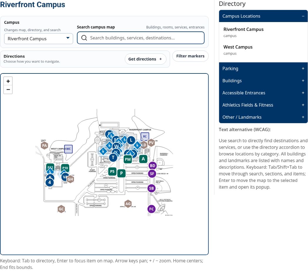
I turned a campus map accessibility problem into a searchable wayfinding tool without purchasing a vendor platform. Built over approximately three months and now live on kcc.edu, the application gives visitors destination and access guidance that a small team can maintain ahead of planned 2027 physical wayfinding improvements.
The problem
KCC relied primarily on static PDF campus maps that were difficult to search and maintain, especially for visitors trying to find a destination.
The college needed better digital wayfinding during its WCAG 2.1 AA readiness work, ahead of planned physical wayfinding improvements in 2027.
Commercial options were evaluated, but timing, cost, and small-team capacity favored an internally maintained bridge.
My contribution
I led the concept, product direction, accessibility approach, content structure, and React/Vite implementation. I built the application incrementally over approximately three months alongside ongoing web, analytics, governance, and accessibility responsibilities.
Research, prototyping, coordination with the Accessibility Program Coordination Group, student testing, and stakeholder reviews guided the work.
The problem with the PDF map model
Perceivable
Campus map information was primarily visual and spatial, making it harder to communicate building relationships, entrances, parking, and services through assistive technology.
Operable
A static PDF map does not naturally support keyboard-based discovery, filtering, searchable destinations, selected locations, or task-based wayfinding flows.
Understandable
Users had to choose from separate map documents and interpret the right PDF rather than search by destination, service, room range, entrance, or access need.
Key decision
I evaluated a commercial wayfinding option alongside continued PDF remediation and an internal build. Timing, cost, small-team capacity, and planned 2027 physical wayfinding work favored an internally maintained bridge focused on immediate navigation needs.
Option 1: Keep remediating PDFs
This would still leave the core wayfinding experience locked inside static visual documents.
Option 2: Buy a vendor platform
This could solve some needs, but it introduced significant setup and recurring cost for a bridge period.
Option 3: Build a bridge
I built an internal React/Vite solution focused on the immediate accessibility, usability, and maintainability gap.
The solution
The application combines interactive maps, directory browsing, and structured location guidance.
Administrative tools support JSON and CSV import/export so campus information can be updated without rebuilding the application.
The bridge supports immediate needs ahead of the planned physical wayfinding improvements.
Explore the features and location fields
Public-facing wayfinding features
- Campus selector for multiple campus contexts
- Searchable destinations and services
- Directory browsing by category
- Marker filtering for buildings, parking, entrances, and landmarks
- Accessible entrance and parking guidance
- Task-based direction modes for common visitor needs
- Visible keyboard guidance and text alternative content
Structured location content
- Location name and building area
- Plain-language description
- Arrival and access notes
- Parking and accessible parking guidance
- Entrance, elevator, and restroom guidance
- Room ranges and exceptions
- Available services and resources by floor
Integration into the public website
I led the product design and built the React/Vite application. My web developer adapted it for integration into KCC’s Jekyll and CloudCannon website. Vite-built JavaScript and CSS load the React interface directly into the Campus Maps page, alongside the college’s shared navigation, page layout, and footer.
KCC’s global Campus Maps footer link gives visitors a consistent entry point to the live tool.
Location guidance
Each marker holds a structured destination record. Entrance guidance can explain general and accessible parking, routes from nearby lots, which entrance to use, elevator and restroom locations, room ranges, and student services.
Plain-language location records make navigation information readable and searchable alongside the visual map.
Maintainable map management workflow
The editing interface supports room, service, entrance, and map-image changes. Editors can click or drag markers and update records through a feature editor connected to the directory.
JSON and CSV export supports updates, import, and handoff for website integration. This gives the small web team a repeatable way to maintain campus information.
Replace map images
Updated map images can be swapped in when rooms, floors, or building diagrams change.
Reposition markers
Markers can be adjusted visually through the editing interface instead of requiring every change to be hard-coded.
Export structured data
JSON and CSV workflows make the location data easier to maintain and hand off for website integration.
Research, testing, and iteration
I reviewed how accessibility-focused community colleges handled campus maps, including how users discover the tool. The live KCC map is available from the global footer.
Five students tested the prototype, and accessibility, facilities, web, and campus stakeholders reviewed it. Feedback led to refinements in interface behavior, labels, guidance, and location content.
Accessibility validation
The system achieved Lighthouse scores of 100 across all categories and was reviewed against WCAG 2.1 AA expectations using keyboard testing and WAVE.
Automated scores are screening results, not a complete measure of accessibility. Manual review and student feedback also informed the experience.
Results
The launched tool supports KCC’s accessibility program and reduces dependence on static PDF maps. The internal approach avoided a premature vendor commitment while preserving capacity for other accessibility work.
- Reduced reliance on static PDF-only campus navigation
- Launched the React/Vite application within KCC’s Jekyll and CloudCannon website
- Provided access through the global Campus Maps footer link
- Created searchable campus destinations and services
- Added keyboard-aware navigation patterns and visible guidance
- Established a maintainable JSON/CSV content management process
- Protected small-team capacity during a heavy accessibility workload
- Created a bridge solution supporting campus navigation until 2027 wayfinding improvements
Next improvements
Next steps include search and failed-search analytics, further usability and screen-reader testing with real users, location review with building managers, and refinements after the planned 2027 physical wayfinding work.